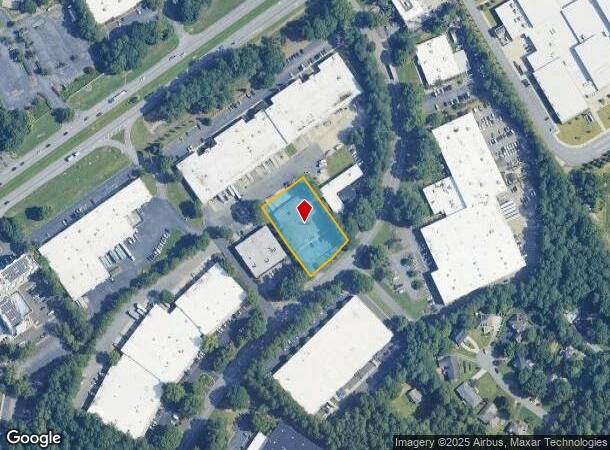
Property Record
5945 Peachtree Cors E, Norcross, GA 30071
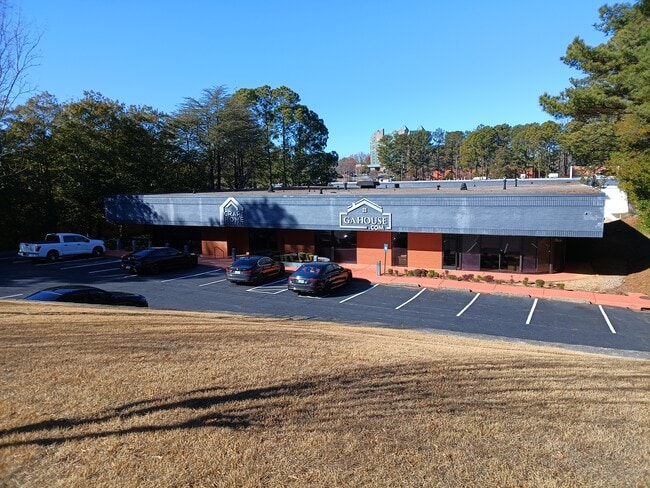

This Property Is For Sale
NEARBY LISTINGS FOR SALE OR LEASE
Property Detail
5945 Peachtree Cors E
Atlanta-Sandy Springs-Roswell, GA
The Crossings
6-273-024
TR NO 7 BLK A THE CROSSINGS
Warehouse
Gwinnett
X
Georgia
13135C0081G
7b
2025
1 AC
2025
Norcross
050311
Atlanta
15,222 SF
DEMOGRAPHICS near 5945 Peachtree Cors E
1 Mile
3 Mile
5 Mile
2024 Total Population
6,283
75,972
240,001
2029 Population
6,501
78,671
246,296
Pop Growth 2024-2029
+ 3.47%
+ 3.55%
+ 2.62%
Average Age
38
37
37
2024 Total Households
2,540
28,109
88,458
HH Growth 2024-2029
+ 3.27%
+ 3.55%
+ 2.55%
Median Household Inc
$81,435
$64,517
$63,527
Avg Household Size
2.40
2.70
2.70
2024 Avg HH Vehicles
2.00
2.00
2.00
Median Home Value
$446,313
$395,861
$374,813
Median Year Built
1989
1987
1986
Nearby Places
Map Layers
Map Styles
 Street
 Aerial
- Restaurants
- Banks
- Shops
- Fitness
- Groceries
PUBLIC TRANSPORTATION
AIRPORT
Hartsfield - Jackson Atlanta International
DRIVE
WALK
Distance
Hartsfield - Jackson Atlanta International
44 min
30.2 mi
Nearby Properties
Address
Land Use
TOTAL SIZE
Lot Size
Zoning
Address
Land Use
TOTAL SIZE
Lot Size
Zoning
599,105 SF
9.13 AC
M1
Address
Land Use
TOTAL SIZE
Lot Size
Zoning
524,000 SF
44.93 AC
RM
Address
Land Use
TOTAL SIZE
Lot Size
Zoning
545,074 SF
53.40 AC
RM8
Address
Land Use
TOTAL SIZE
Lot Size
Zoning
286,481 SF
20.06 AC
M1
Address
Land Use
TOTAL SIZE
Lot Size
Zoning
358,622 SF
31.01 AC
RM13
Address
Land Use
TOTAL SIZE
Lot Size
Zoning
231,192 SF
12.88 AC
RM13
Address
Land Use
TOTAL SIZE
Lot Size
Zoning
303,866 SF
20.13 AC
RM
Address
Land Use
TOTAL SIZE
Lot Size
Zoning
424,948 SF
39.03 AC
RM13
Address
Land Use
TOTAL SIZE
Lot Size
Zoning
426,839 SF
37.47 AC
MUD
Address
Land Use
TOTAL SIZE
Lot Size
Zoning
250,886 SF
22.93 AC
RM13
Address
Land Use
TOTAL SIZE
Lot Size
Zoning
483,279 SF
8.27 AC
BH
Address
Land Use
TOTAL SIZE
Lot Size
Zoning
475,389 SF
5.37 AC
NX
Address
Land Use
TOTAL SIZE
Lot Size
Zoning
249,766 SF
25.34 AC
RM100
Address
Land Use
TOTAL SIZE
Lot Size
Zoning
220,150 SF
21.08 AC
RM13
Address
Land Use
TOTAL SIZE
Lot Size
Zoning
459,745 SF
50.72 AC
RM10
Address
Land Use
TOTAL SIZE
Lot Size
Zoning
420,576 SF
27.06 AC
M2
Address
Land Use
TOTAL SIZE
Lot Size
Zoning
340,962 SF
34.50 AC
PRD
Address
Land Use
TOTAL SIZE
Lot Size
Zoning
255,398 SF
12.45 AC
MUR
Address
Land Use
TOTAL SIZE
Lot Size
Zoning
454,220 SF
30 AC
M1
Address
Land Use
TOTAL SIZE
Lot Size
Zoning
220,915 SF
2.38 AC
HX
Address
Land Use
TOTAL SIZE
Lot Size
Zoning
720,051 SF
99.46 AC
MUR
Address
Land Use
TOTAL SIZE
Lot Size
Zoning
390,776 SF
43.96 AC
RM8
Address
Land Use
TOTAL SIZE
Lot Size
Zoning
225,314 SF
68.32 AC
OI
Address
Land Use
TOTAL SIZE
Lot Size
Zoning
781,705 SF
60.29 AC
M1
Address
Land Use
TOTAL SIZE
Lot Size
Zoning
205,850 SF
24.63 AC
RM10
Address
Land Use
TOTAL SIZE
Lot Size
Zoning
204,333 SF
39.43 AC
RM10
Address
Land Use
TOTAL SIZE
Lot Size
Zoning
399,780 SF
27.24 AC
RM
Address
Land Use
TOTAL SIZE
Lot Size
Zoning
428,933 SF
50.01 AC
PRD
Address
Land Use
TOTAL SIZE
Lot Size
Zoning
336,694 SF
32.05 AC
RM10
Address
Land Use
TOTAL SIZE
Lot Size
Zoning
228,548 SF
16.50 AC
RM10
The World's #1 Commercial Real Estate Marketplace
Connect with us
© 2025 CoStar Group
The information above has been obtained from sources believed reliable. While we do not doubt its accuracy we have not verified it and make no guarantee, warranty or representation about it. It is your responsibility to independently confirm its accuracy and completeness. Any projections, opinions, assumptions, or estimates used are for example only and do not represent the current or future performance of the property. The value of this transaction to you depends on tax and other factors which should be evaluated by your tax, financial, and legal advisors. You and your advisors should conduct a careful, independent investigation of the property to determine to your satisfaction the suitability of the property for your needs.